Why Was This Indicator Chosen?
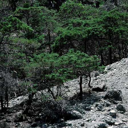
Sargent cypress (Hesperocyparis sargentii) communities occur as open, scrubby forests and woodlands associated with serpentine chaparral. They are relatively limited in distribution and globally rare (LCA, 2009). The “pygmy forest” of Sargent cypress along San Geronimo Ridge is a rare vegetation type that hosts several California Native Plant Society-listed and locally rare plant species.
These communities are good indicators of wildfire and mechanical disturbance. Sargent cypress stands typically recruit new trees following stand-replacing wildland fires, making this a key disturbance process for their long-term persistence. A combination of shade and the properties of serpentine soils make these communities relatively resistant to weed invasion, with the exception of disturbance created by roads, trails, and fuel breaks, which can create a point of entry for some invasive species (LCA, 1995).
What is Healthy?
Maintain more than 360 acres of Sargent cypress communities at the current spatial extent in the One Tam area of focus, supporting the current species richness and structural diversity, and with natural recruitment of Sargent cypress saplings and minimal invasive species.
What Are the Biggest Threats?
- A lack of fire, which plays a critical role in new tree recruitment by stimulating seed dispersal from seratenous cones and creating the bare soil conditions Sargent cypress seedlings need to establish
- Road grading or mowing impacts to trees growing along the shoulder, and invasion by non-native species associated with roads, trails and fuel breaks
- Douglas-fir (Pseudotsuga menziesii) encroachment, though this is less likely to occur in serpentine areas, as Douglas-fir is not as tolerant of those soil types
What is The Current Condition?
The overall condition is Good. Stands have an even-aged appearance, a lack of visible canopy disease, and a low abundance of non-native species (Evens & Kentner, 2006).
What is the Current Trend?
Updates to previous maps done in 2014 revealed that the overall extent of Sargent cypress communities showed No Change. Trends for recruitment levels and invasive species cover are unknown.
How Sure Are We?
We have Moderate confidence in this assessment based on Marin Municipal Water District data on the extent of Sargent cypress communities from 2004 and 2014 (AIS, 2015), and Marin County Parks surveys from 2008 (AIS, 2008).
What is This Assessment Based On?
- MMWD’s original 2004 vegetation map, which was updated in 2009 and 2014 to track the progression of Sudden Oak Death (AIS, 2015)
- MCP 2008 vegetation map, created with a methodology similar to that used by MMWD (AIS, 2008)
What Don’t We Know?
Key information gaps include:
- Ground plots sampled for the 2004 vegetation map should be resampled to determine change in non-native, invasive species abundance
- Burn sites should be monitored for seedling recruitment
resources
Aerial Information Systems, Inc. (2008). Marin County Open Space District Vegetation Photo Interpretation and Mapping Classification Report, prepared by Aerial Information Systems, Inc. for Marin County Parks.
Aerial Information Systems, Inc. (2015). Summary Report for the 2014 Photo Interpretation and Floristic Reclassification of Mt. Tamalpais Watershed Forest and Woodlands Project, prepared by Aerial Information Systems, Inc. for the Marin Municipal Water District.
Evens, J., & Kentner, E. (2006). Classification of Vegetation Associations from the Mount Tamalpais Watershed, Nicasio Reservoir, and Soulajule Reservoir in Marin County, California. Available from: http://www.cnps.org/cnps/vegetation/pdf/mmwd_vegetation_report_2006_06.pdf.
Leonard Charles Associates. (1995). Mt. Tamalpais Area Vegetation Management Plan. Retrieved from https://www.marinwater.org/DocumentCenter/View/212.
Leonard Charles Associates. (2009). Biodiversity Management plan for Marin Municipal Water District Lands. Retrieved from https://www.marinwater.org/DocumentCenter/View/233.


